| Difficulty: |
Medium |
| Major Climbs/Descents: |
Cregneash, Bradda East |
| Total Distance: |
14 miles/23 kilometres |
About the Route
This route goes through quite a few villages as well as deep countryside.
Many ancient sites line the route as well as Harbours and coastline.
A chance to view Lands End for those fit enough for the return uphill.
This is a varied route with a southern feel.
Route Plan
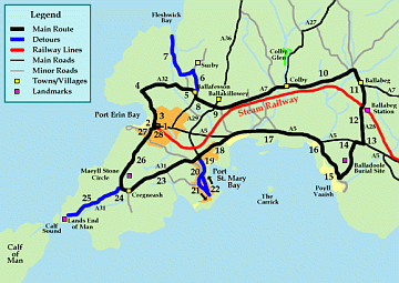 Click for full size image
Ride the Route
- Start at the Port Erin Steam Railway Station.
- Turn left onto Station Road and down to the coast.
- Follow this road right as it turns into the Promenade.
- Continue along this road (Bradda Road) as it climbs up and
to to the right.
- Bradda Road will become Honna Road and after 2 miles you will
be at Ballafesson.
- Detour here to visit Fleshwick Bay with its cove and cliffs. Take
the left turn sign posted for Surby and Fleshwick.
- This is Surby Road (3A or B47) and travels for 1.5 miles to the coast.
Return by the same road back to Honna Road, turn left to rejoin the
route.
- After another 1/4 mile, turn left onto Ballachurry Road.
- Continue straight on past the mini roundabout at Ballakillowey onto
Ballagawne Road (A7).
- Keep on the road through the Colby and Ballabeg villages.
- When the A7 shows Douglas as a left turn,
carry on straight to the A28.
- Pass by Ballabeg Railway Station and keep going to the end of this road.
- Turn right onto the A5 (Note: Busy road).
- After 1/4 mile, turn left through stone gate pillars signposted as
Poyll Vaaish.
- You will pass a gate leading to Balladoole
Burial Site. When you come to the coast and a T-junction, turn right.
- Follow the coastline till you come to the A5 down past Fisher's Hill,
turn left onto it.
- Follow the coast along the Bay ny Carrickey (Note: Busy road with fast
traffic.).
- When you reach Gansey Pottery the road turns right and inland. After
half a mile you will reach a cross roads.
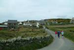
- Detour to the village and harbour of Port St.
Mary, turn left and head down Bay View Road till you are forced
to turn right (3B).
- After 1/4 mile, turn left down Park Road.
- Then left again to down Queens Road till you reach the harbour.
- To return to the main route, ride up Athol Street (one way street)
to High Street and then onto Bay View Road till you reach the cross
roads where you turn left onto Plantation Road.
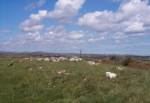
- The road climbs steeply up and after 1.5 miles you reach the village
of Cregneash.
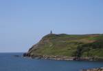
- Detour to the Calf Sound with is wild waters between the mainland and
the Calf of Man (Note: If you take this route it is a long climb
back up the hill to Cregneash.).
- Continue on the A31 (3C) and follow it to Lands End of Man. Return to
the main route by following the same road back up hill to
Cregneash and turn left towards
Port Erin.
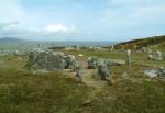
- Turn right towards Port Erin and past the
Meayll Circle on the hill top and
then starts down hill back to
Port Erin.
- After 1.5 miles you will come to Shore Road.
- Turn right uphill on Strand Road till you once again reach Station Road.
This road is one way, so dismount and turn right to return to Port Erin
Steam Railway Station.
| Publications |
Cycling Around the Isle of Man (Cycling with Arnold Robinson)
Arnold Robinson
Walk&Write, Paperback, April, 1996
ISBN: 1874754667
List Price: £4.50
New Price: £6.49
Buy Now
More Info
|
|