
Saturday, May 16, 2026
|
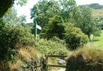
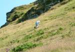
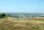
You are here: Isle of Man > Attractions > Early Historical Sites > Promontory Forts HistoryAn unexcavated (Celtic) Iron Age hill fort in the north of the island. The site has dramatic views over the island's northern plain from its 250ft twin peaked position, but with difficult access due to a steep rocky side. Would have been a good defense and watch point. May have been refortified at a later date given the expansion ramparts extending beyond the area of the original fortress. Also known as Primrose Hill and Knoc Sumark Fort.LocationBetween Ballasalla and Ramsey in the North of the Island. The site is accessible from the roadside, though the entrance is only marked by a style and brown sign.Map Ref: SC 392 941 By Vehicle: From Ramsey head along the A3 to Ballaugh. Take the B8 road leading to the A14 near Sulby (Ginger Hall). The site is not far along the B8, just on the left side of the road. By Bus: Take the No 5 or 6 bus from Ramsey, Peel, or Douglas. Get off at Ginger Hall in Sulby and walk to the B8 and along to the site. By Railway: Take the Steam Railway to Douglas and then the Electric Railway to Ramsey. Take the No 5 or 6 bus to Peel and get off at Ginger Hall in Sulby. Walk to the B8 and along to the site. Though it is possible to get to the site by rail, it would be a lot faster to take the bus! |
    |
|
Other Guides by Maxima Systems Ltd: Disney World